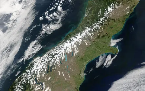

An axial belt with boundary-dependent ends
The official dual name is Southern Alps / Kā Tiritiri o te Moana. The 1998 statutory place-name schedule associates it with Topographical Map 260 sheet F39, grid reference 744444, and 44°20′ S, 168°50′ E.[1] That coordinate is a historical map reference for the named range. It is not a centroid, a summit position, an endpoint or a polygon boundary, so this record does not use it to imply a precisely delimited area.
Published extent depends on what is counted. Te Ara gives a broad length of 500 km from Nelson Lakes National Park toward the entrance of Milford Sound, while a second Te Ara regional account describes more than 500 km between Nelson Lakes and Mount Aspiring / Tititea.[2][3] These are descriptive, differently bounded range lengths rather than competing measurements of one mapped line. This page follows the tighter physical-geography scope: the connected axial belt from the Nelson Lakes–Spenser Mountains sector southwest to the Mount Aspiring area. The Kaikōura ranges branch eastward near the northeastern end; the Fiordland ranges continue southwest but Te Ara treats them as a separate 220 km system built largely from harder crystalline rocks.[2]
The range lies west of the South Island's longitudinal centre. Its Main Divide is a hydrological crest within the mountain system, not a synonym for the whole range; foothill ranges, basins and valleys extend east of it. Administrative boundaries sometimes follow the divide, but they do not define the landform.
The highest crest is close to the western margin
In the central sector the Main Divide and highest massifs stand near the range's western edge. Aoraki / Mount Cook is less than 35 km from the Tasman Sea, while the Alpine Fault marks an abrupt western mountain front above the narrow West Coast lowlands.[3] Eastward, longer valleys descend through high-country basins toward broad outwash surfaces and the Canterbury Plains. The result is a strongly asymmetric cross-section rather than a symmetrical chain.
Aoraki / Mount Cook is the culminating summit at 3,724 m. The figure is not the former 3,764 m height used before a 14 December 1991 rock-and-ice collapse, nor the interim 3,754 m photogrammetric estimate made after that event. A 2 m-resolution model built from February 2008 aerial imagery gave 3,724 m; GNSS measurements made in November 2013 on the ice cap 45 m north of and about 5 m below the true summit agreed with the model to within one metre and confirmed the summit estimate.[4] Because the project page does not identify the vertical datum, the atlas retains the published metre precision without adding a datum claim. The statutory 1998 map coordinate for Aoraki / Mount Cook—43°36′ S, 170°08′ E—is a name-record reference, not the coordinate of the 2013 GNSS observation.[1]
Te Ara lists 24 named South Island summits above 3,000 m and places all of them in the Southern Alps.[2] That count is tied to named peaks and its publication record; it should not be read as a complete inventory of every subsidiary top or as a substitute for a current topographic survey.
Old rocks raised in a young mountain belt
Much of the range is made from 100–300-million-year-old sedimentary rock. Greywacke—a hard sandstone containing mixed rock and mineral fragments, commonly interbedded with siltstone—dominates east of the Main Divide. Toward the west it grades into schist, rock whose minerals and layering were reorganised by heat, pressure and deformation.[6] The bedrock is therefore far older than the present relief: Te Ara places emergence of New Zealand's modern ranges mainly within the last five million years.[6]
The Alpine Fault transfers oblique motion between the Pacific and Australian plates. University of Otago's plate-motion summary resolves that motion into about 36 mm/yr of right-lateral slip—the opposite side moves to the right when viewed across the fault—and about 11 mm/yr of convergence across the boundary. The convergent component thickens and lifts Pacific Plate crust southeast of the fault; some deformation is distributed on faults farther east rather than occurring on the Alpine Fault alone.[5]
These plate-motion components are not summit-growth rates. Displaced river terraces indicate average rock uplift of 10 mm/yr or more in the central Aoraki sector over roughly the past 10,000 years, whereas Te Ara reports about 5 mm/yr along other western parts of the range.[6] A summit can rise more slowly, remain at similar elevation, or collapse while rock below is being uplifted, because rivers, glaciers, landslides and weathering remove material continuously.
Greywacke to schist
Ancient sedimentary rocks become progressively more metamorphosed toward the Alpine Fault.
Slip plus shortening
Right-lateral displacement dominates, but the smaller convergent component builds relief.
Uplift is not height gain
Erosion and slope failure continually offset rock uplift and can abruptly lower individual summits.
Ice has widened valleys and excavated basins
Repeated Quaternary glaciations sent valley glaciers far beyond today's ice limits. They straightened and deepened troughs, cut cirques and hanging valleys, sharpened arêtes, and deposited moraines and outwash. East of the divide, the basins now occupied by lakes Tekapo, Pūkaki and Ōhau were excavated or enlarged by former ice; greywacke gravel carried onward by glaciers and rivers contributed to the coalescing fans of the Canterbury Plains.[3]
The cross-range contrast remains visible in modern glacier form. High snowfields cluster around Aoraki and neighboring massifs. Large eastern valley glaciers such as Haupapa / Tasman occupy long troughs, while steep western glaciers descend from accumulation basins toward lower, wetter valleys.[2][3] Moraine ridges mark former margins, but a moraine-dated maximum, a mapped ice outline and a present terminus are different measurements and should not be interchanged.
Dated inventories replace timeless glacier claims
A 2020 peer-reviewed reconstruction used the 1978 Randolph/GLIMS inventory and classified 2019 Sentinel-2 imagery at 10 m resolution. The 1978 inventory contained more than 3,150 glaciers and 1,463 km² of ice; the study calculated 1,021 km² for 2019, or 69.8% of the 1978 area.[8] The authors' “Southern Alps” inventory domain extends into Fiordland, which they specifically discuss where preserved landform evidence was unavailable. The totals are therefore method-defined regional study figures, not an exact ice census clipped to this page's tighter Nelson Lakes–Mount Aspiring landform scope.
The same study modelled 2019 ice volume at 42.1 ± 8.4 km³ and estimated that 22% of the modelled 1978 volume had been lost by 2019. Its regional volume method carries about 20% uncertainty, and approximately three-quarters of the total volume loss was concentrated in roughly the ten largest glaciers.[8] Many large debris-covered tongues are thinning and stagnating; contact with growing proglacial lakes accelerates frontal loss in some valleys. This explains why a length or terminus position alone cannot describe change across all Southern Alps glaciers.
One divide, two contrasting routes to the sea
West of the Main Divide, rivers such as the Taramakau and Arahura descend swiftly through steep, short catchments to the Tasman Sea. Eastward systems—including the Waimakariri, Rakaia, Rangitātā and Waitaki—cross long glacial valleys, interior basins and piedmont plains before reaching the Pacific. Te Ara identifies these eastern rivers as glacial in origin and explains that, on the plains, they divide into multiple channels across broad beds of glacial outwash.[9]
Braiding is a process, not a fixed channel plan. High and variable flows transport abundant coarse sediment from eroding slopes, moraines and stored valley fill; bars split the flow, and subsequent floods lift gravel from temporary islands and redeposit it downstream. New Zealand's Ministry for the Environment notes that a large flood can create a substantially different arrangement of channels and islands.[9] The range therefore supplies both water and sediment, but the balance varies by catchment, storm, snow season and glacier cover. The dated glacier-loss figures above should not be converted directly into river discharge without a catchment water-balance study.
Westerlies produce a steep west–east gradient
The range lies almost at right angles to New Zealand's prevailing mid-latitude westerlies. Moist air rising across the western slopes cools and condenses, producing orographic rain and high-elevation snow. NIWA's climate synthesis, using the 1971–2000 standard normal and observations interpolated to a 5 × 5 km national grid, describes 3–4 m of annual rainfall in Westland, 12 m or more in the Alps, and less than 500–700 mm in dry parts of Otago and Canterbury.[7] These values describe zones in a gridded regional climatology, not three gauges on one cross-section.
After crossing the crest, descending air warms and dries, creating the eastern rain shadow and at times hot, dry northwesterly föhn winds. Elevation lowers temperature and changes precipitation from rain to snow near the crest; slope exposure and valley orientation create strong local departures from the regional pattern. Seasonal and annual conditions also vary as the strength and direction of circulation change, including with the El Niño–Southern Oscillation and Southern Annular Mode.[7] There is consequently no single useful temperature, precipitation class or snowline for the entire 500 km belt.
A source area linking coasts, basins and plains
The Southern Alps organize the South Island's physical geography at several scales. The Alpine Fault bounds much of the steep western front; the Main Divide separates drainage toward the Tasman Sea and Pacific Ocean; former ice links high cirques to lowland lake basins; and rivers move eroded rock into West Coast lowlands, eastern intermontane basins and the Canterbury Plains.
Those relationships do not make every neighboring highland part of the same feature. The Kaikōura ranges are a northeastern branch, while Fiordland is a southwestern continuation of alpine relief with a different crystalline-rock framework.[2] The European Alps are a separate range system that shares only the generic name. Use the Mountain Hub for other mountain records.
Data sources and publications
- New Zealand Parliamentary Counsel Office. Ngāi Tahu Claims Settlement Act 1998, Schedule 96, “Alteration of place names” (latest version reviewed; accessed 30 August 2026). Source for the official dual names, Topographical Map 260 sheets, grid references and statutory coordinates for Southern Alps / Kā Tiritiri o te Moana and Aoraki / Mount Cook. These are place-name map references, not surveyed range bounds or modern GNSS summit observations.
- Dennis, A., Te Ara – The Encyclopedia of New Zealand. “Mountains: South Island mountains” (published 1 March 2009; updated 1 February 2017; accessed 30 August 2026). Source for the broad 500 km Nelson Lakes–Milford convention, 24 named peaks above 3,000 m, western fault front, eastern ranges and basins, and separation of the 220 km Fiordland ranges.
- McSaveney, E., Te Ara – The Encyclopedia of New Zealand. “Landscapes – overview: Central South Island” (published 1 March 2009; updated 1 July 2015; accessed 30 August 2026). Source for the alternative Mount Aspiring–Nelson Lakes range convention, Aoraki's position less than 35 km from the Tasman Sea, asymmetric relief, glacial valleys and lakes, and sediment transfer to the Canterbury Plains.
- University of Otago, National School of Surveying. “AORAKI2013: surveying the height of Aoraki/Mt Cook” (accessed 30 August 2026). Source for the 1991 collapse and successive 3,754 m and 3,724 m estimates; February 2008 aerial survey; 2 m photogrammetric model; November 2013 Trimble R10 GNSS validation; and the observation position relative to the true summit. No vertical datum is stated on the project page.
- University of Otago, Department of Geology. “Virtual field trip: Alpine Fault” (accessed 30 August 2026). Source for the approximately 36 mm/yr right-lateral and 11 mm/yr convergent plate-motion components and for deformation distributed east of the Alpine Fault.
- Dennis, A., Te Ara – The Encyclopedia of New Zealand. “Mountains: How mountains form” (published 1 March 2009; updated 1 February 2017; accessed 30 August 2026). Source for the young age of the modern relief, 10 mm/yr-or-greater central and approximately 5 mm/yr western uplift rates and their stated timescales, 100–300 Ma greywacke-to-schist bedrock, rainfall-driven erosion and freeze–thaw processes.
- National Institute of Water and Atmospheric Research (NIWA). State of the Climate 2010: A snapshot of recent climate in New Zealand, NIWA Science and Technology Series 56, pp. 8–10 (2010; accessed 30 August 2026), with NIWA's “Inland South Island” climate-zone summary (accessed 30 August 2026). Sources for prevailing circulation, the 3–4 m Westland, ≥12 m alpine and <500–700 mm Otago–Canterbury rainfall zones, the 1971–2000 normal, 5 × 5 km Virtual Climate Station Network method, ENSO/SAM context and dry northwesterly föhn conditions east of the range.
- Carrivick, J. L., James, W. H. M., Grimes, M., Sutherland, J. L. and Lorrey, A. M. “Ice thickness and volume changes across the Southern Alps, New Zealand, from the little ice age to present”, Scientific Reports 10, 13392 (2020). Source for the 1978 Randolph/GLIMS inventory, 10 m Sentinel-2 2019 classification, 1,463 and 1,021 km² ice areas, 42.1 ± 8.4 km³ 2019 modelled volume, 22% modelled volume loss since 1978, concentration of loss in the largest glaciers, lake-terminating glacier response, Fiordland scope note and stated uncertainty.
- Ministry for the Environment and Stats NZ. “Braided rivers: Gravel, water, birds, and farming”, Environment Aotearoa 2019 (accessed 30 August 2026), together with Young, D., Te Ara – The Encyclopedia of New Zealand, “Rivers: Types of river” (published 1 March 2009; accessed 30 August 2026). Sources for west-flowing and east-flowing river examples, glacial-outwash gravel beds, Canterbury braiding and flood-driven channel reworking.