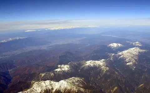

A collective name with uneven boundaries
Japanese Alps—Nihon Arupusu in Japanese usage—covers the Hida Mountains (Kita or Northern Alps), Kiso Mountains (Chuo or Central Alps), and Akaishi Mountains (Minami or Southern Alps). This page uses that three-range physical-geography scope. It does not include every mountain in central Japan: Mount Fuji, the Yatsugatake volcanic group, and Mount Ontake are separate features. The range system crosses parts of Niigata, Toyama, Nagano, Gifu, Yamanashi, and Shizuoka prefectures, but prefectural and park boundaries do not define its natural edges.
“Minami Alps” needs particular care. An Environment Ministry regional account uses it for the Akaishi high range together with the neighboring Ina and Minobu mountains, whereas the three-part Japanese Alps convention equates the Southern Alps with the Akaishi Range. The wider administrative or regional usage should not be added to the area of the Japanese Alps as if both were identical. Likewise, there is no authoritative whole-system polygon, centroid, or single length to report. A published dimension is available for the Kiso component: the ministry describes it as approximately 100 km north–south and 20 km east–west, between the Kiso and Ina valleys. (Ministry of the Environment, Central Alps designation; Minami Alps park plan)
Ranges separated by basins and river corridors
The Hida Range is the northern and northwestern block, extending through the high country of Toyama, Niigata, Nagano, and Gifu. Its internal groups include the Ushiro-Tateyama, Tateyama, and Yari–Hotaka ridges and the volcanic massifs around Yakedake and Norikura. Okuhotaka is its highest listed summit at 3,190 m (36°17′21″N, 137°38′53″E). The Matsumoto basin and adjoining lowlands lie east and southeast of this block. (GSI mountain catalogue; Chubusangaku National Park)
South of the Matsumoto–Shiojiri lowland, the narrow Kiso Range rises between the Kiso Valley on the west and the north–south Ina Valley on the east. Kiso-Komagatake is its highest summit at 2,956 m (35°47′22″N, 137°48′16″E). Across the Ina Valley, the broader Akaishi Range carries parallel high ridges through Nagano, Yamanashi, and Shizuoka. Mount Kita's 3,193 m summit stands in its northern Shirane group; the range continues south through the Shiomi, Arakawa, Akaishi, and Hijiri massifs. These summit coordinates orient the component ranges; they are not boundary points for the collective system. (GSI mountain catalogue)
Okuhotaka, 3,190 m
A faulted, partly volcanic and heavily dissected northern block with documented modern glaciers and abundant inherited glacial relief.
Kiso-Komagatake, 2,956 m
A roughly 100-by-20-km granitic ridge sharply bounded by the Kiso and Ina river valleys.
Mount Kita, 3,193 m
A deeply incised block built largely from deformed accretionary rocks; modeled rapid uplift applies to its northern sector.
Three ranges with different construction histories
The label “island-arc mountains” describes the regional setting, not a single formation event. In the Hida Range, granitic and older metamorphic rocks occur alongside young volcanic centers. A synthesis of dated volcanic deposits and basin gravels found two main Hida episodes of igneous activity and uplift, at about 2.5–1.5 million years ago and from about 0.8 million years ago to the present. The study interprets the earlier phase as partly buoyant response to magma added within the crust and the later phase as compression acting on crust already weakened by intrusion; these are proposed mechanisms for the Hida Range, not an age for every rock in it. (Oikawa, 2003)
The Kiso Range is a non-volcanic ridge formed almost entirely in granitic rock, according to the 2020 Central Alps designation. Frost cracking, rockfall, and streams exploit joints in that rock, while rivers have cut steep valley walls on both sides. The Akaishi Range differs again: much of its main body consists of Cretaceous-to-Miocene accretionary complexes—ocean-floor and trench sediments scraped from a subducting plate, stacked, folded, and later raised—while granite forms the Kaikoma–Hou sector. The range lies in the deformation zone where the Izu–Ogasawara arc meets Honshu. (Ministry of the Environment, Kiso geology; Minami Alps park plan, pp. 132–134)
Thermochronology and fault modeling resolve the northern Akaishi Range as a west-tilted thrust block beside the Itoigawa–Shizuoka Tectonic Line fault zone. The model uses 5–7.5 mm per year of reverse slip and estimates both bedrock uplift and denudation at roughly 4 mm per year. Those are model results for the northern range, not a measured rate for all three Japanese Alps; the authors explicitly allow a different uplift history in the southern Akaishi Range. Deep valleys are therefore not incidental scenery: river erosion and slope failure remove rock while tectonic movement raises the range. (Sueoka and others, 2017)
Cirques and troughs concentrated near high crests
Quaternary glaciers occupied selected high valleys rather than covering the Japanese Alps as one ice cap. In the northern Hida Range, cirques—armchair-shaped hollows excavated at glacier heads—and U-shaped troughs are especially well developed around Tateyama, Yakushidake, Yarisawa, and Karasawa. A Geological Survey of Japan mapping report for the Tateyama district records abundant glacial landforms and deposits, particularly on the eastern and northern sides of the main ridge. Snow avalanches, rockfall, and rivers have continued to steepen and rework those inherited forms. (GSJ, Geology of the Tateyama District; Ministry of the Environment)
Glacial evidence also occurs farther south but is more localized. South of Kiso-Komagatake, the Kiso ridge preserves cirques, moraines—ridges of debris deposited by ice—and small glacial lakes. In the Akaishi Range, cirques and cold-climate patterned ground survive near high summits, including Senjogatake and the Arakawa group. Their presence records colder late-Pleistocene conditions; it does not mean that modern glaciers occupy all three ranges. (Central Alps designation; Minami-Alps National Park profile)
Flow separates a glacier from a persistent snow patch
Heavy drift accumulation allows ice to persist in shaded hollows of the northern Hida Range. A glacier must deform or slide under its own weight; surviving summer snow alone is not enough. Ground-penetrating radar and geodetic surveys reported ice thicker than 30 m at the Kakunezato and Ikenotan patches and motion greater than 2 m per year, so both were classified as active glaciers. Kuranosuke contained about 25 m of ice but moved only 3 cm per year and was interpreted as an active glacier transitioning toward a perennial snow patch; Hamaguriyuki showed no flow and was not classified as a glacier. (Fukui, Iida, and Kosaka, 2018)
These are observations of four named ice bodies during specified surveys, not a complete timeless glacier count. Their mass balance depends strongly on avalanche-fed snow accumulation and local topography. The same study found more than 900 m difference between calculated equilibrium-line altitudes at Kuranosuke and Kakunezato, showing why a single regional snowline is misleading in this steep, wind-redistributed snow environment.
Headwaters divided among two coasts
In the Hida Range, short headwaters radiate away from high massifs rather than following one axial valley. The Environment Ministry identifies the Kurobe flowing north, the Azusa south, the Takase east, and the Gamata west from the central national-park highlands. Kurobe and Gamata–Jinzu water reaches Toyama Bay; the Azusa and Takase join the Sai–Shinano system, which crosses the Nagano and Niigata basins before reaching the Sea of Japan. Confined valleys carry abundant coarse sediment from steep slopes into fans and downstream basins. (Chubusangaku National Park terrain; MLIT Shinano basin)
The Kiso Range forms a particularly legible divide. Western tributaries enter the Kiso River, which follows the Kiso Valley and ultimately reaches Ise Bay; eastern tributaries descend to the Tenryu in the Ina Valley. The Tenryu runs between the Kiso Range on the west and Akaishi Range on the east, then turns through mountain gorges to the Pacific at Enshu-nada. MLIT measures its main channel at 213 km and its basin at 5,090 km²; these figures describe the entire river basin, not the Japanese Alps. The Akaishi Range also supplies headwaters to the Oi and Fuji systems on its eastern and southern sides. (MLIT Kiso system; MLIT Tenryu profile; Minami-Alps headwaters)
Winter snow west and north; summer rain south and east
In winter, the Siberian High and Aleutian Low drive northwesterly air across the Sea of Japan. The air gains moisture over the sea, rises against central Honshu's mountains, and produces heavy snow on windward slopes; descending air is drier on the Pacific side. This mechanism makes the northern and western Hida Range a deep-snow environment and helps maintain its perennial snow and small glaciers. It also creates sharp differences across short distances, so a valley station or one snow patch cannot stand for the whole system. (Japan Meteorological Agency)
The balance changes southward and seasonally. The Environment Ministry characterizes the Akaishi highlands as wetter in summer and less snowy in winter than the northern Japanese Alps. Early-summer tsuyu rainfall and later tropical cyclones contribute to the Pacific-side wet season, while elevation and slope exposure control where rain and snow fall. Intense runoff through fractured and deformed rocks promotes V-shaped valleys, debris movement, and rapid channel response; seasonal snowmelt adds a spring-to-early-summer pulse, especially in the Hida catchments. (JMA seasonal climate overview; Minami-Alps National Park profile)
Data sources and publications
- Geospatial Information Authority of Japan. 3D Map: Major Mountains of Japan (accessed 30 August 2026). Official range assignments, elevations, published summit coordinates, alternate peak names, and measurement-revision notes for Mount Kita, Okuhotaka, and Kiso-Komagatake.
- Ministry of the Environment, Japan. Designation of Chuo Alps Quasi-National Park, 27 March 2020. Kiso Range alias, approximate 100-by-20-km dimensions, bounding valleys, granitic geology, and mapped glacial landforms.
- Ministry of the Environment, Japan. Characteristics of Chubusangaku National Park (accessed 30 August 2026). Hida subranges, faulted and volcanic relief, outward-flowing headwaters, heavy snow, cirques, and U-shaped valleys.
- Ministry of the Environment, Japan. Minami Alps National Park Management Plan, pp. 132–134 (English section; accessed 30 August 2026). Wider Minami Alps terminology, Akaishi subdivisions, accretionary-complex geology, granite sector, and Izu–Honshu arc collision.
- Oikawa, T. “The Spatial and Temporal Relationship between Uplifting and Magmatism in the Hida Mountain Range, Central Japan,” The Quaternary Research 42.3 (2003), 141–156. Dated Hida uplift and igneous episodes and proposed mechanisms.
- Sueoka, S., Ikeda, Y., Kano, K., and others. “Uplift and denudation history of the Akaishi Range, a thrust block formed by arc-arc collision in central Japan,” Journal of Geophysical Research: Solid Earth 122 (2017), 6787–6810. Northern Akaishi thermochronology, fault-model geometry, slip, uplift, denudation, and limits on extrapolation southward.
- Harayama, S., Takahashi, Y., Nakano, S., Kariya, Y., and Komazawa, M. Geology of the Tateyama District. Geological Survey of Japan, 1:50,000 quadrangle report, written 1999 and published 2000. Northern Hida bedrock and distribution of glacial landforms and deposits.
- Fukui, K., Iida, H., and Kosaka, T. “Newly Identifying Active Glaciers in the Northern Japanese Alps and Their Characteristics,” Geographical Review of Japan Series A 91.1 (2018), 43–61. Ground-penetrating-radar ice thickness, geodetic flow, glacier classification, area changes, and equilibrium-line contrasts.
- Japan Meteorological Agency. Overview of Japan's Climate (accessed 30 August 2026). Winter pressure pattern, northwesterly monsoon, and Sea of Japan–Pacific snowfall contrast.
- Ministry of Land, Infrastructure, Transport and Tourism. Tenryu River, Kiso River System, and Shinano River Basin (accessed 30 August 2026). Valley orientation, receiving seas, basin dimensions, upper-basin relief, and sediment connections.
- Ministry of the Environment, Japan. Minami-Alps National Park Profile (accessed 30 August 2026). Akaishi summer-rain and winter-snow contrast, Oi–Tenryu–Fuji headwaters, and high-elevation glacial and periglacial forms.