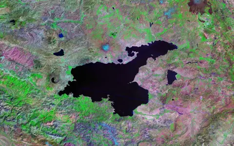

The lake, not every place called Van
Lake Van is the accepted English name; scientific literature also gives the Turkish name Van Gölü. This page covers the standing-water body, its submerged basins, shoreforms, and the drainage and geological processes directly connected to it. It does not use “Van” to mean Van Province, the city of Van, the whole closed drainage basin, nearby Lake Erçek, or the small lake inside Nemrut caldera.[5]
The eastern and northern shores lie mainly in Van Province and the western and southwestern shores in Bitlis Province. Van stands east of the water, Erciş faces the northeastern gulf, and Tatvan occupies the southwestern end. Nemrut rises immediately west of Tatvan, Süphan borders the northwestern sector, and the Bitlis Massif forms the steep southern catchment. Low-gradient plains and deltas are concentrated around the Erciş gulf and the eastern shore, where the principal rivers enter.[2][4]
Area, volume, and elevation need dates
A 2024 hydrological synthesis reports a water surface of about 3,550–3,620 km² during 1973–2020. For its 1943–2016 reconstruction it gives a mean area near 3,580 km² and a volume range of about 560–575 km³, averaging 568 km³. These are level-dependent reconstructions, not immutable dimensions. The same study estimates the deepest point as 452.9 m below a lake surface at 1,648.33 m; recent geological literature retains 451 m as the standard mapped maximum.[1][2]
Other reputable compilations inherit different morphometries. The World Lake Database lists 3,713 km² and 607 km³, while a hydrochemical survey used 3,522 km² and 576 km³. The difference is too large to treat as rounding, and those records do not provide one common shoreline date and polygon method. This page therefore uses the dated 3,550–3,620 km² range for recent surface scale and does not combine area from one source with volume from another to manufacture a mean depth.[5][9]
Gauge elevation also varies. The 1944–2020 Tatvan series, reproduced from Türkiye's State Hydraulic Works (DSİ), ranges from 1,646.67 m in September 1956 to 1,650.53 m in March 1989 and June 1995—reported as a 3.85 m spread from the underlying unrounded observations. The publishing study does not restate the gauge's vertical datum, so these values are retained as one internally consistent station series rather than combined with satellite or map elevations.[1]
Connected sub-basins divided by ridges
Lake Van is not a simple western trough and eastern shelf. Modern seismic and multibeam work distinguishes the deep Tatvan Basin, the Ahlat sub-basin, the Northern Basin, and the smaller Deveboynu Basin, separated or bordered by structural highs. A recent synthesis places the Tatvan floor near 450 m water depth, the Ahlat sub-basin near 410 m, and the Northern Basin near 260 m; the intervening ridges and most shelves are shallower than 150 m.[2][3]
The Tatvan Basin is approximately enclosed by the 400 m depth contour and covers about 400 km². The Northern Ridge is roughly 30 km long and 5 km wide and rises about 300 m above the Tatvan floor, separating it from the much smaller Northern Basin. Ahlat Ridge separates the main deep from Ahlat sub-basin, while the small Deveboynu Basin lies farther east. These are submerged structural divisions within one connected lake, not separate lakes.[3]
Tatvan Basin
The largest deep floor, fault-bounded and approximately outlined by the 400 m depth contour.
Ahlat and Northern basins
Ahlat Ridge and Northern Ridge divide smaller deep sectors from the Tatvan Basin.
Shelves, deltas, and channels
River-built shallows and submerged channels record sediment delivery and former lower shorelines.
More than 1,500 km of reflection profiles show prograding deltas, faults, and large mass-transport deposits—sediment moved downslope by slumps and debris flows. The deep basins remained water-covered through major late Quaternary lowstands, while the shelves repeatedly emerged and were cut by rivers. That history explains the submerged channels and relict deltas tens of kilometres from some modern mouths.[4][5]
Faulting, subsidence, and a volcanic threshold
Lake Van lies in the actively deforming East Anatolian collision zone. Seismic interpretations show grabens and half-grabens—down-dropped fault blocks—formed during extension early in the preserved lake history. From about 340,000 years ago, compression and sideways movement also built push-up ridges such as the Northern and Ahlat highs. The basin is therefore tectonic in origin even though volcanoes dominate its western and northern skyline.[3]
The preserved lacustrine sequence records initial flooding at about 600,000 years ago, but that date describes development of the long-lived endorheic lake recorded by sediment and seismic data, not the age of every part of the underlying depression. Researchers infer that lava and thick ignimbrite sheets from the Nemrut volcanic system helped separate the Van depression from the Muş basin and obstruct an older western drainage route. Because the barrier is reconstructed from buried and eroded geology, “closed by Nemrut volcanism” is better supported than attributing closure to one named eruption.[3][4]
Past closure was not necessarily permanent at every level. A porewater-salinity reconstruction identifies highstands about 105 m above its 1,645 m reference surface at roughly 135,000 and 248,000 years before present. At that elevation the modelled basin spills from a southwestern threshold toward the upper Tigris drainage. This inferred highstand overflow is a different route and time from the older western connection toward the Muş basin.[8]
Snowmelt enters; evaporation removes water
The Zilan and Bendimahi rivers descend into the Erciş gulf from the north and northeast; together they supplied about 40% of measured annual runoff in the 1989–1990 hydrochemical survey. The Karasu enters from the east, the Engil from the southeast, and shorter streams reach the lake near Tatvan, Ahlat, and the southern shore. Runoff peaks in spring as rain and snowmelt reach the river network; an older hydrological analysis estimated that more than 80% of annual discharge arrived during that season.[5][7]
Catchment figures differ because they describe different boundaries. The 2024 hydrological study gives 12,500 km² for land draining directly to Lake Van while excluding other lakes in the closed basin, and about 15,500 km² when those lake sub-basins are included. The World Lake Database lists 10,000 km² without the same boundary note. These values are not interchangeable measurements of a single polygon; this record uses 12,500 km² only when referring to the direct land drainage specified by the study.[1][9]
No modern river carries water out. A frequently cited long-term budget assigns about 4.2 km³ per year to lake-surface evaporation, balanced by 2.5 km³ of surface runoff and 1.7 km³ of precipitation directly onto the lake. Those are generalized long-term means, not present-day meter readings. Evaporation has not been measured over the whole water surface; station pans and models disagree, and a 2010–2020 study could not reproduce every observed level change with its simplified budget. Groundwater must also not be assumed absent: mapped freshwater springs discharge through the lake floor.[1][2][7]
A soda lake with a slowly renewed deep layer
“Soda lake” refers to carbonate-rich alkaline water, not simply salty water. Lake Van's measured composition is dominated by sodium, carbonate, chloride, and sulphate, with pH around 9.7–9.8 and total salts around 21–22 g per kilogram—less saline than typical ocean water but much more alkaline. Calcium brought by rivers and groundwater is removed efficiently as carbonate minerals, helping sustain the unusual chemistry.[2][5][6]
Freshwater input creates measurable spatial and seasonal structure. In May 2005 the upper 20 m of open water was at least 0.5 g kg−1 fresher than deep water, and surface water in the river-fed Erciş gulf was 2.5 g kg−1 fresher than open-lake water. Summer warming adds a thermal density difference, but the persistent salinity increase with depth can keep the water column stable even in winter. Deep renewal is therefore intermittent rather than an automatic annual overturn.[6]
The deep-water state changes with the hydrological regime. Measurements in 1990 found oxygen at the bottom, whereas profiles in 2005 found anoxia below about 325 m and tracer ages indicated a roughly 17-year residence time for that isolated deep water. The study linked the change to reduced renewal following a roughly 2 m lake-level rise. These observations are dated states, not evidence that the lake is permanently oxygenated or permanently anoxic at one fixed depth.[5][6]
Groundwater builds towers on the shelves
Lake Van's submerged microbialites are rock-like carbonate structures built where calcium-rich groundwater mixes with alkaline lake water. Seismic profiles and underwater surveys find them from nearshore water to about 130 m depth, commonly aligned along faults and fractures. A 2024 study sampled 9 m and 15 m towers at 25 m depth and found that focused spring flow through internal channels, carbonate precipitation, and microbial growth together construct the columns.[2]
Diffuse groundwater produces flatter carbonate crusts instead. At river mouths, mixing can form pale suspended “whitings” of fine calcium carbonate that settle as light layers in the sediment rather than tall towers. The microbialites and whitings are therefore related expressions of groundwater or river water meeting a carbonate-rich soda lake, not generic coral reefs or volcanic chimneys.[2]
A shoreline sensitive to continental water balance
The basin has cold, wet winters and warm, dry summers. Annual precipitation near the lake is commonly summarized at about 400 mm, much of it winter snow and spring rain; surrounding elevation stores part of that water until snowmelt. River discharge is greatest in late spring, while summer evaporation and reduced inflow lower the lake. Gauge observations from 1944–2006 show the seasonal level commonly peaking in late spring or early summer and falling toward autumn and winter, with annual ranges as large as 0.9 m.[2][6]
Longer changes shift deltas, beaches, and shallow-water landforms. The Tatvan gauge rose about 2 m from 1988 to 1995, then fell roughly 1.5 m by 2003. On much longer timescales, seismic profiles, terraces, and porewater chemistry record highstands about 105 m above and a regression about 200 m below the modern reference surface during the past 250,000 years. Those reconstructions operate at different temporal resolutions: the sediment-porewater method resolves changes over tens of thousands of years and cannot reproduce individual historical seasons or years.[6][8]
Across the approximately 600,000-year seismic record, major lowstands coincide mainly with glacial periods, supporting climate as the dominant large-scale control, while fault displacement and volcanic barriers may alter basin shape and thresholds. Shoreline movement should therefore be interpreted first through precipitation, runoff, and evaporation, without ruling out tectonic or volcanic contributions where independent geological evidence exists.[10]
A terminal lake between major river systems
Water inside the modern Lake Van catchment converges on the lake. Beyond the divides, drainage runs outward toward the upper Euphrates and Tigris systems; those external river basins must not be counted as present Lake Van catchment. The older connection toward the Muş basin and modelled highstand spill toward the upper Tigris show that thresholds have changed through geological time, but neither is a modern surface outflow.[3][8]
Lake Van belongs in the lake hub as a deep endorheic soda lake. Its Zilan, Bendimahi, Karasu, and Engil inflows connect it to the river hub; its fault ridges, volcanic threshold, deltas, submerged channels, and terraces connect it to the terrain index.
Sources and measurement notes
- Aydin, M. C., Gelberi, G. and Ulu, A. E., “Investigation of recent level changes in Lake Van using water balance, LSTM and ANN approaches”, Applied Water Science 14, article 41 (2024). Source for the 1973–2020 area range; 1943–2016 mean area and volume range; depth recalculated at a stated lake level; direct versus whole-basin drainage areas; DSİ 1944–2020 gauge series; water-budget inputs and evaporation-method limits.
- Çağatay, M. N., Damcı, E., Bayon, G. and Sarı, M., “Microbialites on the northern shelf of Lake Van, eastern Türkiye: Morphology, texture, stable isotope geochemistry and age”, Sedimentology 71, 850–870 (2024; first published 2023). Source for the 3,712 km² reference area, 607 km³ volume, 451 m maximum depth, sub-basin depths, catchment geology, seasonal climate and inflow, water chemistry, sub-lake springs, and measured microbialite form and distribution.
- Cukur, D. et al., “Structural characteristics of the Lake Van Basin, eastern Turkey, from high-resolution seismic reflection profiles and multibeam echosounder data: geologic and tectonic implications”, International Journal of Earth Sciences 106, 239–253 (2017). Source for fault-bounded sub-basin geometry, ridge dimensions, extensional and compressional stages, the tectonic-basin interpretation, and the qualified reconstruction of volcanic closure near Nemrut.
- Cukur, D. et al., “Seismic stratigraphy of Lake Van, eastern Turkey”, Quaternary Science Reviews 104, 63–84 (2014). Source for the 1,500 km seismic dataset, 130 km WSW–ENE axis, initial flooding, prograding deltas, sub-basin history, and mass-transport deposits.
- Reimer, A., Landmann, G. and Kempe, S., “Lake Van, Eastern Anatolia, Hydrochemistry and History”, Aquatic Geochemistry 15, 195–222 (2009). Source for the Van Gölü name, reference coordinates, the 3,522 km²/576 km³ alternative morphometry, 451 m bathymetric maximum, 1989–1990 survey methods, tributary chemistry and runoff shares, submerged channels, relict deltas, and carbonate processes.
- Kaden, H. et al., “Impact of lake level change on deep-water renewal and oxic conditions in deep saline Lake Van, Turkey”, Water Resources Research 46, W11508 (2010). Source for the 2004–2008 CTD and tracer methods; chart bathymetry at a 1,646 m surface; seasonal and 1988–2003 level changes; salinity gradients; stable deep stratification; dated oxygen profiles; and the 17 ± 3 year deep-water residence estimate.
- Altunkaynak, A., Özger, M. and Şen, Z., “Triple diagram model of level fluctuations in Lake Van, Turkey”, Hydrology and Earth System Sciences 7, 235–244 (2003). Source for the spring concentration of runoff and the long-term 4.2 km³ evaporation, 2.5 km³ runoff, and 1.7 km³ direct-precipitation balance. These values are retained as generalized period means, not current observations.
- Tomonaga, Y. et al., “Porewater salinity reveals past lake-level changes in Lake Van, the Earth's largest soda lake”, Scientific Reports 7, article 313 (2017). Source for the method limits, reconstructed +105 m highstands and approximately −200 m regression during the past 250 ka, and the modelled highstand overflow toward the upper Tigris.
- International Lake Environment Committee, Lake Van, World Lake Database record ASI-251 (accessed 29 August 2026). Source for the alternative 3,713 km² surface, 607 km³ volume, and 10,000 km² catchment entries. The record does not state a matching shoreline date or boundary method, so its figures are not merged with dated hydrological reconstructions.
- Cukur, D. et al., “Water level changes in Lake Van, Turkey, during the past ca. 600 ka: climatic, volcanic and tectonic controls”, Journal of Paleolimnology 52, 201–214 (2014). Source for the seismic reconstruction of major lowstands and the conclusion that climate was the dominant long-term control while volcanic and tectonic processes also contributed.