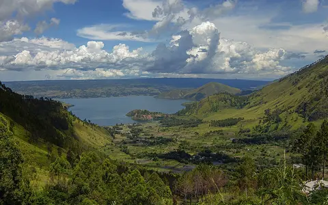

The lake, not every place called Toba
This record covers the physical water body and the immediate landforms that shape it. “Toba” can also mean the wider volcanic complex, its caldera or the Toba–Asahan river system. Samosir's land area and the caldera rim are therefore not counted as lake surface. The Smithsonian catalogue point at 2.6083° N, 98.8417° E locates the Toba volcanic complex, not a surveyed lake centroid.[4]
A LIPI morphometric study mapped 1,124 km² of open water from 2010 Landsat imagery and calculated 256.2 km³ of volume from acoustic bathymetry collected in 2009–2010. Its 228 m mean depth is volume divided by mapped area. The study measured 508 m in the northern basin and 420 m in the southern basin. An older 1939 cable sounding gave 529 m; a 2003 echo sounder gave 505 m. These values differ by survey method and coverage, so this page uses 508 m as the principal modern mapped maximum and retains 505–529 m as the documented survey range—not as evidence of 24 m of basin-wide infilling.[2][3]
The former “about 1,700 km²” statistic did not describe open water. The World Lake Database reports about 1,100 km² of water but 1,780 km² when Samosir and Pardapur islands are included. Its 87 km lake length also differs in scope from the Smithsonian's 100 km dimension for the enclosing caldera.[1][4]
A high basin in the Barisan Mountains
Lake Toba lies in North Sumatra Province, about 150 km south of Medan, within the volcanic Barisan chain that follows Sumatra's western side. The lake trends northwest–southeast. Haranggaol and Tongging lie around the northern reach; Pangururan is on Samosir's western margin; Parapat faces the island from the east; and Porsea stands near the southeastern outlet sector.[1][6]
Reference works commonly place the surface at about 904–905 m above sea level, but they do not state a vertical datum and the water level is not fixed. For scale, Indonesia's BMKG reported +903.12 m on 17 March 2026 and an operational low-water indicator of +902.40 m; those dated management elevations should not be substituted for a timeless natural “elevation.” The surrounding caldera walls rise roughly 400–1,200 m above the lake in the ILEC basin description, concentrating runoff into a comparatively compact upland catchment.[1][3][9]
A composite caldera, not a single crater
The Toba volcanic complex records four major Pleistocene ignimbrite-producing eruptions beginning about 1.2 million years ago. An ignimbrite is rock formed from hot, ground-hugging ash and pumice flows. The latest caldera-forming event produced the Young Toba Tuff about 74,000 years ago. Overlapping collapse structures produced the elongated 35 × 100 km caldera that the modern lake only partly fills.[4]
Collapse was followed by resurgence: broad uplift of the caldera floor rather than construction of one simple cone. Samosir and the lower Uluan block to its east are the main raised structures. Radiocarbon-dated lake sediments show that Samosir's upper surface was submerged about 33,700 years ago; the eastern side has since risen about 700 m while the western side remained near lake level, creating a west-tilted block. The uplift estimate describes deformation since the sediment surface was at lake level, not the present height of every point on Samosir.[5]
35 × 100 km caldera
The Smithsonian dimensions describe the volcanic depression, not the water surface.
Tilted Samosir block
Former lake sediments now stand hundreds of metres above the water on its eastern side.
Uluan and lava domes
Uluan rose less than Samosir, while later domes added local volcanic relief inside the complex.
Two deep basins around Samosir
The water body is not one uniform bowl. The 2009–2010 mapping divided it into a 586.16 km² northern basin containing 155.67 km³ of water and a 537.84 km² southern basin containing 100.52 km³. The north therefore held about 61% of the surveyed volume and contained the 508 m maximum near Haranggaol; the southern maximum was 420 m. Samosir and the intervening shallows constrain exchange between these large compartments.[2]
Steep caldera scarps approach much of the outer shore, while lower gradients occur at stream mouths, on the Porsea outlet sector, and along parts of Samosir. The lake's narrow western connection beside Pangururan is now the Tano Ponggol channel. A Ministry of Public Works project described widening that existing 1.2 km passage from 25 to 80 m and deepening it from 3 to 8 m. Samosir is consequently an island in current hydrographic use, but its geologic identity is a resurgent block of caldera fill capped by former lake sediment.[4][8]
A compact catchment and one outward route
An automated watershed delineation in the LIPI study measured 2,486 km² of land draining toward 1,124 km² of lake—a land-catchment-to-water ratio of 2.21:1. Streams descend from the rim and from Samosir, with more mapped inflow concentrated around the southern basin. Direct rainfall falls on nearly one-third of the combined land-and-water basin represented by those measurements, so both precipitation on the lake and tributary runoff matter to storage.[2]
The Asahan River leaves the southeastern basin and runs toward the Strait of Malacca. A 2014 isotope-sampling programme tested rainfall, springs, inflowing streams, lake water and the upper Asahan. The lake carried a stronger evaporation signal than the inflows, while upper-Asahan isotope values closely matched the lake, confirming that lake water dominated the outlet sample. This supports the physical distinction between the compact Lake Toba catchment and the larger Asahan system downstream.[6]
Lake level changes with rainfall, evaporation and outflow rather than remaining at the rounded 904–905 m reference elevation. Its large volume damps short pulses, but drought and managed release still matter. Historical discharge averages quoted at the downstream Siruar station decline from 110.4 m³/s for 1920–1932 to 90 m³/s for 1976–1988; because the periods and water-management context differ, those figures are not presented as a current natural discharge rate.[2][9]
Tropical rainfall above a persistent deep layer
The near-equatorial setting supplies year-round solar heating, while the roughly 900 m lake elevation keeps the basin cooler than North Sumatra's coastal lowlands. The World Lake Database's archival 1961–1980 series for Parparean reports a 19.1 °C annual mean, only 18.8–19.4 °C among monthly means, and 1,732 mm annual precipitation. Every month in that station series received at least 83 mm. These values describe one named station and an old 20-year period, not a current basin-wide climate normal; the high rim also makes local rainfall exposure uneven.[1]
Depth strongly limits whole-lake circulation. LIPI profiles from April 2009, October 2009 and April 2010 placed the actively mixed upper layer roughly in the top 30 m, a transition layer from about 30 to 100 m, and comparatively stable deep water below 100 m; the authors classified Toba as oligomictic, meaning complete mixing is infrequent and irregular. Their dissolved-oxygen measurements fell below 2 mg/L at and below 200 m in the sampled profiles.[2]
A later study sampled 14 sites periodically from 2016 through 2019 and described stratification as permanent, with the deep hypolimnion beginning at about 80 m while the surface epilimnion shifted with atmospheric conditions. The two studies use somewhat different layer boundaries because sampling periods, stations and definitions differ; together they support persistent deep stratification, not a claim that every boundary remains fixed through the year.[7]
From the Sunda Arc to the Malacca coast
Toba interrupts the Barisan highlands with a large, high-standing water surface inside the Sunda volcanic arc. Water entering the caldera drainage converges on the lake, passes through the southern basin, and follows the Asahan southeastward through lower terrain to the Strait of Malacca. The lake is therefore open at the local scale and part of an ocean-draining river system at the regional scale.[1][4]
Compare its deep volcanic basin through the lake hub, follow its sole outflow through the river hub, or place its caldera scarps and resurgent blocks in the terrain index.
Sources and measurement notes
- International Lake Environment Committee Foundation, “Danau Toba (Lake Toba)”, World Lake Database (accessed 29 August 2026). Used for the published geographic envelope, North Sumatra and Barisan setting, approximate 905 m elevation, single Asahan outlet, named places, 87 km length and the explicitly archival 1961–1980 Parparean climate series. The database's “1,780 km² including islands” is not treated as water area, and its datum is not stated.
- Lukman & I. Ridwansyah, “Kajian Kondisi Morfometri dan Beberapa Parameter Stratifikasi Perairan Danau Toba”, Limnotek 17(2), 158–170 (2010), Indonesian Institute of Sciences (LIPI), now hosted by BRIN. Landsat ETM+ scenes from January and March 2010 supplied shore area; 2009–2010 acoustic transects sampled depth at 50–100 m intervals. Source for 1,124 km² area, 256.2 km³ volume, 228 m mean and 508 m maximum depths, basin partition, 2,486 km² land catchment, historical Siruar discharge series and sampled stratification.
- Moedjodo, H., Simanjuntak, P., Hehanussa, P. & Lufiandi, “Lake Toba: Experience and Lessons Learned Brief”, International Lake Environment Committee (2006). Source for the 904 m approximate surface elevation, 87 km length, 400–1,200 m rim relief, Asahan drainage and reconciliation of the 529 m 1939 cable sounding with the 505 m 2003 echo sounding.
- Smithsonian Institution, Global Volcanism Program, “Toba”, volcano profile 261090 (accessed 29 August 2026). Source for the volcanic-complex catalogue coordinate, Sunda Arc setting, 35 × 100 km caldera dimension, four major Pleistocene ignimbrite eruptions since about 1.2 Ma, approximately 74 ka Young Toba Tuff, and the Samosir–Uluan resurgent structures. Catalogue elevation 2,157 m belongs to the volcanic feature and is not used as lake elevation.
- Mucek, A. E., Danišík, M., de Silva, S. L. et al., “Resurgent Toba—field, chronologic, and model constraints on time scales and mechanisms of resurgence at large calderas”, Frontiers in Earth Science 3:25 (2015). Source for the radiocarbon-constrained former lake sediments, approximately 33.7 ka submergence, westward tilt and about 700 m eastern Samosir uplift. The paper notes that Toba's coherent post-caldera chronology remains incomplete.
- Sidauruk, P., Pratikno, B. & Pujiindiyati, E. R., “Isotopic Characterization of Precipitation, Inflow, and Outflow of Lake Toba as a First Assessment of Lake Water Balance Study”, Atom Indonesia 44(1), 1–7 (2018), DOI 10.17146/aij.2018.547. Twelve months of 2014 rainfall sampling plus inflow, spring, lake and outlet samples support the evaporation and Asahan-source statements.
- Sidauruk, P. et al., “Lake Toba stratification study with physical, chemical, and isotopic parameter approach”, Environmental Monitoring and Assessment 195, 897 (2023). Source for 14-site observations from 2016–2019, the approximately 505 m depth context, permanent-stratification interpretation, approximately 80 m hypolimnion boundary and climate-sensitive upper layer.
- Indonesia Ministry of Public Works and Housing, Infrastructure Development Agency, “Pelebaran Alur Tano Ponggol” (31 July 2019; accessed 29 August 2026). Source only for the existing channel's 25 m width and 3 m depth and the project's 80 m, 8 m and 1.2 km design dimensions.
- Indonesia Meteorology, Climatology, and Geophysics Agency (BMKG), “Jelang Musim Kemarau, BMKG dan PJT I Gelar OMC untuk Penuhi Kebutuhan Air di Danau Toba” (9 April 2026; accessed 29 August 2026). Source for the explicitly dated 17 March 2026 water-level reading and +902.40 m operational low-water indicator. The public item does not identify a vertical datum.