
The lake, not the wider Onega catchment
This record covers the standing-water body and its submerged basin. “Onega” can also refer to the 53,100 km² land catchment, to the regulated Upper Svir reservoir system of which the lake is the main storage body, or to unrelated places such as the Onega River flowing to the White Sea. Those are not interchangeable geographic features. The International Lake Environment Committee (ILEC) gives bounding coordinates of 60°55′–62°55′ N and 34°14′–36°30′ E; those limits describe a rectangle around the lake, not a centroid or a point coordinate.[1][3]
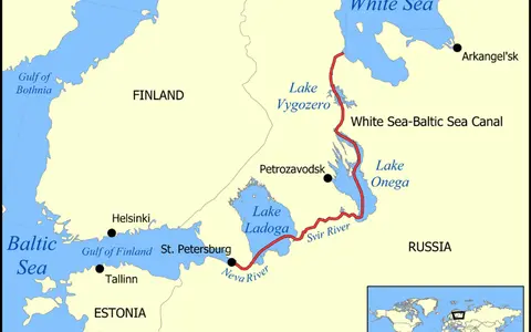
Petrozavodsk faces Petrozavodsk Bay on the western side. Kondopoga Bay and Povenets Bay indent the northwest and north, while the Zaonezhye Peninsula and its archipelago divide the northern water into long arms. The eastern shore receives the Vodla; the southeastern and southern sector receives rivers including the Andoma and Vytegra; the Svir leaves the southwestern end. Administrative boundaries cross the shoreline, but the lake is one connected physical basin.[1][2][3]
Why published area and depth figures differ
Recent papers drawing on the Karelian Research Centre's 2010 Lake Onego: Atlas use 9,720 km² for water surface, about 295 km³ for volume, 30 m for mean depth, and 120 m for maximum depth. The ILEC profile, assembled from a 1990 questionnaire, instead lists 9,890 km², 280 km³, and the same 120 m maximum. Neither source exposes a shoreline polygon, reference water level, or bathymetric calculation method on its summary page. The two area–volume sets should therefore not be blended into a false-precision average; this page uses the internally consistent atlas-derived set and identifies it as a published reference figure rather than a timeless surveyed area.[1][2]
A 2023 isotope and water-balance study reports a 132.5 m greatest depth in the central lake, while the lake-atlas and ILEC summaries use 120 m. The paper does not explain whether 132.5 m comes from a newer sounding, a different lake level, or a different bathymetric grid. Until that lineage is documented, 120 m remains the conventional maximum in the overview and 132.5 m is retained here as an unresolved alternative—not silently substituted.[1][2][3]
Ancient rock beneath a young postglacial lake
The age of the surrounding bedrock is not the age of Lake Onega. In the north and west, the basin meets exposed or shallow Precambrian rocks of the Fennoscandian Shield. Around the northern shores and Zaonezhye are Paleoproterozoic sedimentary and volcanic successions; farther south and southeast, younger sedimentary strata cover the East European Platform. The broad geological boundary runs roughly between the mouths of the Shuya on the west and Vodla on the east.[1][5]
Older depressions and rock structures supplied the framework; repeated Fennoscandian ice sheets then scoured, widened, and filled them with glacial deposits. The modern lake emerged as the last ice sheet withdrew from the region roughly 12,000–11,000 years ago. That is a deglaciation interval, not an exact birthday: meltwater routing, outlet thresholds, land uplift, and shoreline position continued to change afterward.[1][5]
The structural contrast remains visible. ILEC describes the northern floor as deep hollows of 90–100 m separated in places by ridges only 1–2 m below the surface. Long, narrow bays, cliffs, skerries, and islands follow the resistant rock. The southern basin is broader and flatter, with a reported mean depth near 30 m and more low, marsh-fringed shores developed on sediment-covered terrain.[1]
Shield-controlled relief
Hard Precambrian rocks support steep points, long bays, islands, deep troughs, and shallow rock ridges.
Platform margin
Younger sedimentary cover and glacial deposits accompany a flatter floor and generally lower shores.
Postglacial water body
The rock framework is ancient, but the present lake developed after regional ice retreat about 12,000–11,000 years ago.
River-dominated inflow, one regulated outlet
The river network is far denser than the old phrase “dozens of rivers” suggests. A Karelian Research Centre inventory counts 1,152 tributary watercourses, including 52 rivers longer than 10 km. The Vodla, Shuya, and Suna together contribute about 60% of river discharge. The Shuya enters Petrozavodsk Bay from the west, the Suna feeds the Kondopoga sector, and the Vodla reaches the eastern shore; this uneven delivery helps make bays respond more quickly to catchment runoff than the open lake.[2][3]
For the water balance summarized in the 2023 isotope study, rivers supply about 76% of incoming water, or 17.1 km³ per year; precipitation falling directly on the lake supplies about 24%, and direct groundwater discharge is less than 1%. The Svir carries about 18.8 km³ per year—84% of water loss—toward Lake Ladoga, while evaporation accounts for the remaining 16%. These are long-term balance estimates, not a forecast for any individual year.[3]
Snowmelt is visible in both level and isotope records. Lake level is usually lowest in April before spring breakup and highest in June or July. Snowmelt flooding has its strongest short-term effect in river-fed bays; across the open lake, summer precipitation and evaporation become more evident later in the season. The Svir discharge is controlled at the Upper Svir hydroelectric dam, so the level cycle is a managed hydrological regime superimposed on runoff, precipitation, and evaporation—not a wholly natural lake hydrograph.[3]
Two overturn seasons and a variable winter cover
Lake Onega is dimictic: much of the water column mixes in spring and again in autumn, with stratification between those periods. During spring warming, shallow coastal water warms first while the open lake remains close to the temperature of maximum freshwater density. A moving front called a thermal bar separates those water masses, temporarily limiting exchange between nearshore bays and colder offshore water.[1][2]
Ice timing is too variable for a fixed “November to May” rule. Satellite-based daily series for 2000–2018 found ice phenomena lasting 132–203 days, with a 171-day mean; complete freeze-up lasted 11–137 days, averaging 90. The mean date of complete freeze-up in that period was 16 January. These figures describe the study period and the full lake surface, unlike older observations made mainly from Petrozavodsk Bay.[4]
Air temperature strongly shifts the calendar. In the 2000–2018 analysis, a 1°C change in the relevant early-winter mean corresponded to roughly five days' change in complete freeze-up, while a 1°C change in April–May corresponded to about three days' change in complete ice clearance. Wind, snowfall, stored summer heat, currents, and rapid day-to-day expansion or breakup of ice add spatial variation, so bays can freeze while central Onega remains open.[4]
Upstream of Ladoga, the Neva, and the Baltic Sea
Following the water downstream gives the physical hierarchy: Lake Onega drains through the Svir into Lake Ladoga; Ladoga drains through the Neva into the Gulf of Finland, an arm of the Baltic Sea. Onega is therefore a distinct lake basin, an upstream storage component of the Neva drainage system, and a receiving basin for a much larger forest-and-wetland catchment. Those nested scales explain why lake area, catchment area, and the wider Svir–Ladoga basin must be labeled separately.[1][3]
For wider comparison, return to the lake hub, follow the outlet through the river systems hub, or compare Onega's glacial and bedrock-controlled relief in the terrain index.
Sources and measurement notes
- International Lake Environment Committee, Lake Onego, World Lake Database (accessed 29 August 2026). Source for the Lake Onego spelling, administrative and coordinate bounds, shield–platform setting, north–south basin contrast, principal islands, single Svir outlet, conventional 120 m maximum depth, dimictic classification, and the older 9,890 km²/280 km³ measurement set. The profile was supplied by questionnaire from sources including a 1990 volume and retains obsolete administrative wording; its figures are treated as a historical database record, not silently mixed with the later atlas-derived set.
- Zobkov, M. et al., “Data on the chemical composition of Lake Onego water in 2019–2021”, Data in Brief 42, 108079 (2022). Source for the 9,720 km² surface, 295 km³ volume, 30 m mean and 120 m maximum depths, 53,100 km² catchment, 1,152 tributary watercourses, leading inflows, river share of water input, shield–platform division, twice-yearly mixing, and spring thermal bar. Its morphometry is attributed to the Karelian Research Centre's 2010 Lake Onego: Atlas.
- Borodulina, G., Tokarev, I. and Yakovlev, E., “Isotope Composition of Natural Water in Lake Onega Basin”, Water 15(10), 1855 (2023). Source for the 2009–2018 isotope study, 225 km² island area, 17.1 km³/yr river input, 18.8 km³/yr Svir loss, precipitation/groundwater/evaporation shares, 52 rivers longer than 10 km, seasonal level sequence, snowmelt and evaporation effects, dam regulation, dimictic circulation, and the alternative 132.5 m maximum-depth figure. The paper does not reconcile that depth with the conventional 120 m value.
- Baklagin, V. N., “Variations of indicative dates of ice regime on Lake Onego based on ground air temperature”, Advances in Oceanography and Limnology 10(1) (2019). Source for the lake's approximately 248 by 96 km bounding dimensions and the 2000–2018 satellite-derived duration, complete-freeze date, and temperature sensitivity of ice phases. The study used MODIS, NSIDC, and NOAA satellite products and meteorological stations around the lake; its period statistics are not presented as fixed future dates.
- Eckelmann, R. et al., “Mobility and community at Mesolithic Lake Onega, Karelia, north-west Russia: insights from strontium isotope analysis”, Archaeological and Anthropological Sciences 17, 17 (2025). Source for the formation interval after Fennoscandian ice retreat, the geological division between exposed Precambrian shield rocks and the sediment-covered East European Platform, and the specific Archean, Paleoproterozoic, and younger bedrock provinces around the shores. The bedrock ages are not used as an age for the modern lake.