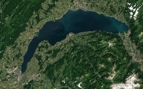

One lake, several mapped sectors
Lake Geneva is the established English name for the whole water body; Le Léman or Lac Léman is used in French, and Genfersee in German. The Swiss federal topographic data model treats Le Léman as the overall lake and lists Grand Lac, Petit Lac, Haut Lac, Lac de Genève, and La Rade as names for lake parts. Those sector names do not denote separate lakes.[1]
This page covers the entire connected lake surface and basin from the Rhône delta at the eastern head to the Rhône outlet in Geneva. It does not use “Lake Geneva” for the wider 7,419 km² land catchment, the Geneva urban region, or only the western Lac de Genève sector. The international boundary divides jurisdiction, not the underwater basin.[3]
From the Chablais to Geneva
The Rhône enters between Villeneuve and Le Bouveret at the lake's narrow eastern head. From there the lake opens westward between the Swiss north shore—principally the cantons of Vaud, with Valais at the head and Geneva at the outlet—and the French department of Haute-Savoie on the south shore. The 2016 Federal Office for the Environment (FOEN) lake sheet assigns about 40% of the surface to France; that is an administrative partition of the same physical lake.[3]
Relief is most confined around the Haut Lac, where the Chablais and Vaud Alps rise close to the delta. Farther west, the north shore adjoins the Swiss Plateau and the basin broadens across the Grand Lac; the Jura lies beyond the northwestern shore. The Petit Lac then tapers southwest from the Yvoire–Nyon line to Geneva. This east–west sequence provides a clearer orientation than describing every shore as uniformly “mountain-rimmed.”[3][4]
A deep main basin and a shallow outlet arm
The Grand Lac, east of the Yvoire–Nyon axis, is the broad principal basin. A hydrodynamic study using measured and modelled lake data gives it a 309 m maximum depth, about 160 m mean depth, and roughly 10 km mean width. The Petit Lac to the west is narrower—about 4.5 km mean width—and reaches only about 70 m. These are basin-scale summaries; the official Vaud bathymetric products use multibeam sonar and nearshore LiDAR to represent much finer relief on the Swiss part of the bed.[4][5]
CIPEL reports a mean water-surface elevation near 372 m and a maximum water depth of 309.7 m. Subtracting those rounded values places the deepest lake bed roughly 62 m above sea level, not below it. Buried bedrock may lie much lower beneath sediment, but bedrock elevation, sediment thickness, and water depth are different measurements and should not be combined.[2]
Broad, 309.7 m deep
The central and eastern main basin holds the maximum depth and most of the lake's volume.
Narrow, about 70 m deep
The western arm carries lake water toward the Rhône outlet at Geneva.
Delta-facing eastern reach
This named sector surrounds the Rhône entry and the steep, sediment-active head of the lake.
Repeated glaciation cut and refilled the foreland basin
The basin is not simply a single glacier scoop. Beneath the western lake, seismic profiles show a major erosion surface cut across folded and thrust Tertiary foreland-basin rocks. Repeated Quaternary advances of Rhône ice eroded that substrate; retreat phases then left glacial, meltwater, and lake sediment. In the Petit Lac, the mapped Quaternary fill is locally as much as 220 m thick and contains erosion surfaces produced by readvances during the last deglaciation.[6]
This evidence separates three stages often blurred together: older Alpine tectonics formed and deformed the bedrock setting; glaciers and subglacial water enlarged the depression; and sediment progressively infilled parts of it as the ice withdrew and the lake developed. The cited seismic reconstruction applies specifically to the western Petit Lac, so its 220 m fill thickness is not presented as a lake-wide value.[6]
Alpine runoff routed through a regulated outlet
The hydrological catchment covers 7,419 km² of land when the lake surface is excluded. CIPEL separately publishes a rounded 8,000 km² basin figure; the 580.1 km² difference is almost exactly the lake surface, indicating that the two totals use different boundary conventions rather than competing land-area estimates. This page keeps the FOEN land-only definition explicit. The Rhône supplies about three quarters of the inflow. The Dranse is the largest French tributary, while the Venoge and Aubonne drain the Swiss north shore.[2][3]
At Porte du Scex, about 5 km upstream from the mouth, the Rhône's mean discharge for 1970–2021 was 185 m³/s. The same study measured a May–October high-flow-season mean of 245 m³/s, reflecting snowmelt and high-altitude runoff; these figures describe the upstream Rhône station, not total lake inflow or outlet flow. At Geneva, water leaves as the Rhône. The Arve joins downstream in the city and is therefore part of the lower Rhône system, not a Lake Geneva tributary.[7]
The lake level is managed at the Seujet dam in Geneva. Under the current regulation, the normal upper range is 372.15–372.30 m from June through December and the normal low range is 371.60–371.75 m from mid-March to mid-April; every fourth year the target is lowered another 0.15 m for shoreline works. The commonly quoted “372 m elevation” is therefore orientation, not a fixed water level.[8]
A river plume above an active sublacustrine delta
The Rhône is the main source of both water and mineral sediment. During stratified conditions, field measurements show its cold, sediment-bearing water plunging beneath the surface and travelling as an interflow—a density current within the thermocline rather than along the bed. In September 2021 measurements, that layer occupied roughly 10–30 m depth near the mouth; turbulence along its lower edge aggregated fine clay and silt into larger flocs that settled more rapidly. The observed depths describe that campaign, not a permanent plume level.[7]
Coarser sediment builds the subaerial and underwater Rhône delta, while density currents route material through incised sublacustrine channels toward deep water. Sediment can also move abruptly: seismic profiles and cores support a large lake tsunami in AD 563 associated by the study with failure near the Rhône delta. That event is evidence of episodic mass movement in a sediment-rich lake basin, not a claim that ordinary river plumes generate tsunamis.[9]
Seasonal layering and incomplete winter turnover
Spring and summer warming produces a light surface layer above colder deep water. In winter, surface cooling increases density and wind supplies mechanical energy, but a lake this deep mixes to the bed only in sufficiently cold, windy conditions. MétéoSwiss identifies the two main channelled wind regimes as the northeasterly bise and the usually southwesterly Vent; the narrowing gap between Jura and Alps strengthens the bise toward the Petit Lac. Local summer lake breezes reverse between day and night as land and water heat at different rates.[10]
CIPEL's latest available winter assessment reported mixing to about 140 m in 2026, well short of the 309 m deep basin. Winter 2025–2026 was the fourteenth consecutive winter without complete mixing; the last complete turnover was in 2012. This dated observation matters because incomplete turnover limits vertical exchange with the deepest water. It does not mean the lake is motionless: winds drive waves, basin-scale currents, upwelling, and lateral exchange even while the water column remains thermally layered.[11]
From Alpine headwaters to the Mediterranean
Lake Geneva is a storage and sediment-trapping reach of the Rhône, not the river's source or endpoint. Upstream, the catchment extends through Valais into high Alpine snow and glacier country. Downstream, the Rhône leaves Geneva, receives the Arve, crosses into France, and ultimately reaches the Mediterranean. The lake therefore interrupts but does not end the river corridor.
Use the lake hub to compare other through-flow basins, the river hub to follow continental drainage, and the terrain index for the glacial, deltaic, and Alpine-foreland landforms represented here.
Sources and measurement notes
- Federal Office of Topography swisstopo, Catalogue des objets swissTLM3D 1.7 (March 2019; accessed 29 August 2026), p. 55. Source for Le Léman as the whole mapped lake and La Rade, Lac de Genève, Petit Lac, Grand Lac, and Haut Lac as named lake sectors.
- Commission internationale pour la protection des eaux du Léman (CIPEL), Le Léman en chiffres (accessed 29 August 2026). Source for the current published 580 km² area, 309.7 m maximum depth, 89 km³ volume, approximately 372 m mean surface elevation, 11.3-year theoretical residence time, 200.2 km shoreline, and rounded 8,000 km² basin figure. SHL2 is identified as the monitoring station at the deepest point.
- Swiss Federal Office for the Environment (FOEN), Le Léman: Qualité de l'eau du lac, lake factsheet dated 1 July 2016 (accessed 29 August 2026), pp. 2 and 7. Source for the Yvoire–Nyon basin division, Rhône share of inflow, named tributaries, 7,419 km² land catchment, 580.1 km² surface, approximately 153.4 m mean depth, and the approximately 60% Swiss / 40% French surface split. Catchment land-cover figures in that sheet use 2006 data and are not repeated here.
- Baracchini, T. et al., “Data assimilation of in situ and satellite remote sensing data to 3D hydrodynamic lake models: a case study using Delft3D-FLOW v4.03 and OpenDA v2.4,” Geoscientific Model Development 13, 1267–1284 (2020; accessed 29 August 2026). Source for the 46.458° N, 6.528° E literature map reference and the Grand Lac/Petit Lac depth and mean-width summaries. The coordinate is not represented as an official centroid.
- État de Vaud, Mise à jour des données bathymétriques du lac Léman (18 October 2017; accessed 29 August 2026). Source for the Swiss bathymetric grid/isobath products, multibeam-sonar positioning correction, and 2016 nearshore LiDAR coverage. This page does not claim that the dataset covers the French lake bed.
- Fiore, J., Girardclos, S., Pugin, A., Gorin, G. and Wildi, W., “Würmian deglaciation of western Lake Geneva (Switzerland) based on seismic stratigraphy,” Quaternary Science Reviews 30(3–4), 377–393 (2011; accessed 29 August 2026). Source for the western-lake erosion surface, repeated Rhône-glacier retreat and readvance record, and locally 220 m thick sequence of glacial, glaciolacustrine, and lacustrine deposits. Its mapped thickness applies to the Petit Lac study area.
- Piton, V. et al., “From Particles to Flocs: Revealing Where Flocculation Occurs in the Nearfield of a Negatively-Buoyant River Plume in a Large Lake (Lake Geneva),” Journal of Geophysical Research: Oceans 129 (published 31 January 2024; accessed 29 August 2026). Source for the 1970–2021 Rhône discharge statistics at Porte du Scex and the September 2021 measurements of plume interflow, suspended sediment, turbulence, and floc formation. Campaign depths are not generalized to all seasons or discharges.
- État de Genève, La gestion des niveaux du lac (accessed 29 August 2026). Source for Seujet regulation, seasonal normal-level bands, the four-year 0.15 m lowering, and the explanation that inflow includes rainfall, snowmelt, and soil drainage.
- Kremer, K., Simpson, G. and Girardclos, S., “Giant Lake Geneva tsunami in AD 563,” Nature Geoscience 5, 756–757 (2012; accessed 29 August 2026). Source for the seismic-profile and sediment-core evidence of the AD 563 event and the modelled link to mass failure near the Rhône delta.
- Federal Office of Meteorology and Climatology MeteoSwiss, Les vents du Léman (accessed 29 August 2026). Source for the bise, Vent, Jura–Alps channeling, Haut Lac wind distinctions, and summer thermal-breeze regime.
- CIPEL, État de santé du Léman : entre absence de brassage complet, réussite de la restauration et vigilance écologique (30 March 2026; accessed 29 August 2026), pp. 1 and 3–4. Source for the approximately 140 m winter mixing depth in 2026, the fourteen consecutive winters without complete turnover, the last complete turnover in 2012, and the cold-and-wind controls on deep mixing.