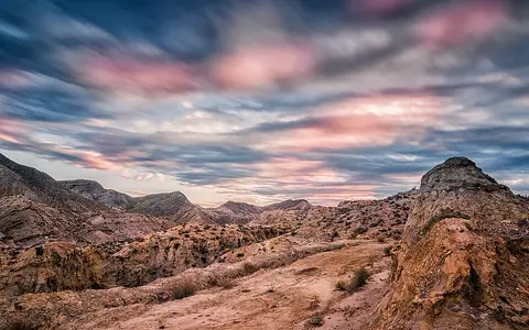

Three overlapping geographic frames
Tabernas Desert and Tabernas badlands are landscape names, not surveyed land parcels. Scientific papers also use Tabernas sub-desert for the badland study area. This record uses “Tabernas Desert” for the semi-arid badlands and their immediate basin setting; it does not treat every surface inside the Tabernas Basin as badland terrain.[4][5]
The Tabernas Basin is the larger geological depression: the official field guide describes it as an approximately 20-km-long, east–west basin, no more than about 10 km wide, continuing east toward the distinct Sorbas Basin. The Desierto de Tabernas protected area is a legal polygon of 11,448.49 ha across the municipalities of Tabernas, Gádor, Santa Cruz, Alboloduy and Gérgal. Its 114.48-km² equivalent must not be relabelled as the natural desert's exact area.[1][2]
Between Filabres and Alhamilla
The basin lies inland from the Mediterranean-facing lowlands of Almería. Metamorphic basement of the Sierra de los Filabres bounds its northern side; Sierra Alhamilla forms the strong southern relief. Eastward, the basin fill passes axially into the Sorbas Basin, but late-Miocene uplift and deformation gave the two basins different depositional histories. The town and municipality of Tabernas locate the feature administratively but do not define its physical limits.[2][7]
Badlands occupy especially dissected sectors of the basin fill, while fans, terraces, cultivated flats, bedrock hills and mountain footslopes form transitional margins. The legal protected area extends beyond the municipality of Tabernas into four other municipalities, further demonstrating why “desert,” “basin” and “municipality” are not interchangeable map units.[1]
From deep marine trough to exposed sediment
Tabernas was a tectonically active marine basin during the late Miocene. Kleverlaan's basin reconstruction places an early Tortonian submarine-fan system in water at least 600 m deep and estimates total basin subsidence on the order of 1,200 m. Those are reconstructed ancient water-depth and subsidence values, not modern elevations. As sediment accumulated and the bordering ranges rose, the basin shallowed; parts emerged before gypsum formed in the still-submerged western sector during the Messinian.[3]
Modern remapping shows that the seabed was not a simple level trough. Strike-slip faults and folds created local depressions in which sediment-laden density flows were ponded. These turbidity currents laid down alternating sandstone and mud; slumps and debris-rich mass movements added deformed beds. One fault-bounded sub-basin preserves more than 300 m of ponded turbidites, debrites and slumps, a local thickness rather than the thickness of the whole basin fill.[7]
Calcareous mudstone
Fine marine sediment containing carbonate; much of the pale, easily weathered badland slope material is marl or mudstone.
A gravity-flow deposit
Sand and mud laid down by sediment-laden flows moving across the ancient sea floor.
Buried fill raised and folded
Late-Miocene to later deformation changed a site of deposition into exposed, eroding terrain.
Dissection of soft, layered rock
The best-studied badlands at El Cautivo are developed chiefly on Tortonian marine marl of the Chozas Formation. Weathering breaks down the gypsum-bearing, calcareous mudstone; runoff then follows small differences in gradient and surface condition. Closely spaced rills and gullies leave steep slopes and narrow interfluves, while tougher sandstone beds form ledges and dip slopes. Piping—subsurface removal of fine sediment—can create cavities and short tunnels before roofs collapse.[4][5][6]
The landscape is a mosaic rather than uniformly bare, rapidly eroding ground. Slope aspect influences moisture, plant cover and surface crusts; biological soil crusts made by cyanobacteria, lichens and other organisms can bind particles and sharply reduce soil loss. Laboratory rainfall simulations on intact 20-cm samples found that soil loss declined by roughly an order of magnitude along the studied sequence from physical crusts to more developed biological crusts. Because slope was held constant and the samples were small, that result describes crust erodibility, not a basin-wide erosion rate.[6]
A regional review also cautions that Tabernas's dramatic relief does not imply exceptionally large present erosion everywhere: rainfall events are often too small or infrequent to mobilize much sediment, and stable, crusted or vegetated patches respond differently from bare slopes. Erosion is concentrated where rainfall intensity, antecedent moisture, surface condition and connection to a channel align.[4][5]
Ramblas route short flood pulses
A rambla is a broad channel that is normally dry but can carry storm runoff. In Tabernas, ramblas are the main sediment and water routes. During floods, several channels may divide around sandy bars, producing a braided pattern; flow can erode banks and beds in one reach and deposit sand or gravel in another. The Rambla de Tabernas is the principal named trunk through the basin and joins the Andarax drainage downstream, linking the interior badlands to the Mediterranean rather than ending in a permanently closed basin.[2]
The Andalusian field guide attributes the large rambla valleys to uplift, an arid but storm-responsive climate and erodible basin fill. It describes incision and widening over approximately the last 100,000 years, with local valleys approaching 100 m in depth and channel belts exceeding 100 m in width. These are rounded examples from the basin, not dimensions for every rambla, and the guide does not state a survey method or vertical datum.[2]
At smaller scales, runoff generation depends strongly on surface type. Six hydrological years of monitoring at El Cautivo showed greater runoff coefficients and erosion on small bare microcatchments than on fully vegetated ones. Water and sediment therefore move in pulses through a connected hierarchy—from slope patches to gullies and then ramblas—rather than as a continuous desert river.[4]
A dry Mediterranean regime with large variability
Research at Tabernas describes the climate as semi-arid and thermo-Mediterranean: dry summers, most rainfall outside summer and a large year-to-year water-supply variation. The basin lies leeward of the Sierra de los Filabres, Sierra Nevada and Sierra de Gádor with respect to important rain-bearing flows. Mountain shelter operates together with the seasonal circulation of the Mediterranean region, not as a guarantee that storms never reach the basin.[4]
The most traceable long record cited by recent field research is from the former official Tabernas station at 37°03′10″N, 2°23′27″W and 490 m above sea level. For 1967–1997 it averaged 235 mm of precipitation per year, with 36% interannual variability. This is a historical station mean for a stated 30-year period; it is neither a current climate normal nor a uniform total for the protected area or basin.[6]
A separate El Cautivo record illustrates sensitivity to site and period: the six hydrological years from 1991–92 through 1996–97 averaged 250.7 mm, ranged from 151 to 416.7 mm and had a 39% coefficient of variation. Those figures should not be averaged with the 30-year station value. Low annual totals coexist with occasional effective storms, but many events are small; both scarcity and event concentration help explain the alternation of long surface stability with short episodes of runoff and sediment transfer.[4]
A small dryland with a large geological record
Tabernas is geographically useful because its modern dryland surface exposes several older environments at close range: subaerial fans, a deep marine basin, submarine gravity-flow deposits, fault-controlled relief, later gypsum and Quaternary river incision. The neighboring Sorbas Basin continues the late-Miocene basin belt eastward but is not an eastern subdivision of the Tabernas Desert.[2][3][7]
Within the Desert Hub, compare Tabernas as a compact, water-eroded badland system rather than by repeating unsupported claims that it is Europe's “only,” “largest” or “driest” desert. Its clearest measurements belong to a protected polygon, a geological basin, individual outcrops and named weather stations; each remains attached here to that source scope.
Sources and measurement notes
- Junta de Andalucía, “Paraje Natural Desierto de Tabernas” and Valores Ambientales de los Espacios Protegidos Red Natura 2000: ES0000047 Desierto de Tabernas (accessed 29 August 2026). Sources for the current 11,448.49-ha protected polygon, its five municipalities and legal scope. An older 2004 RENPA table gave 11,625 ha; this page uses the newer mapped Natura 2000 value rather than combining them.
- Villalobos Megía, M. (ed.), Braga Alarcón, J. C. (scientific supervisor) et al., Geology of the Arid Zone of Almería, South East Spain: An Educational Field Guide—The Tabernas Basin (ACUSUR and Regional Ministry of Environment, Junta de Andalucía, 2003). Source for the approximately 20-by-10-km basin frame, its relationship to the Filabres, Alhamilla and Sorbas Basin, landform terminology, ramblas, drainage evolution and rounded local valley dimensions. The guide does not state measurement methods or datums for those dimensions.
- Kleverlaan, K., “Neogene history of the Tabernas basin (SE Spain) and its Tortonian submarine fan development”, Netherlands Journal of Geosciences 68, 421–432 (1989). Source for the structural-depression setting, reconstructed early-Tortonian water depth of at least 600 m, approximately 1,200 m of total basin subsidence, submarine-fan development, regression, western-basin gypsum and later emergence. These are palaeogeographic reconstructions, not present-day measurements.
- Cantón, Y., Domingo, F., Solé-Benet, A. & Puigdefábregas, J., “Hydrological and erosion response of a badlands system in semiarid SE Spain”, Journal of Hydrology 252, 65–84 (2001). Source for the El Cautivo six-hydrological-year method and 1991–97 rainfall statistics, the leeward mountain setting, Chozas Formation description and contrasting runoff response of bare and vegetated microcatchments.
- Solé-Benet, A., Cantón, Y., Lázaro, R. & Puigdefábregas, J., “Weathering and erosion in the Tabernas Sub-Desert, Almería”, Cuadernos de Investigación Geográfica 35(1), 141–163 (2009; online record published 2013). Used for the semi-arid badland classification, gypsum-calcareous mudstone, weathering and surface-cover mosaic, and the caution that dramatic relief does not imply uniformly high current erosion.
- Lázaro, R., Gascón, C. & Rubio, C., “Runoff and soil loss in biocrusts and physical crusts from the Tabernas Desert (southeast Spain) according to rainfall intensity”, Frontiers in Microbiology 14, 1171096 (2023). Source for the former official Tabernas station's coordinates, 490-m elevation and 1967–1997 precipitation statistics; late-Pleistocene badland-development context; surface-crust terminology; and the controlled 20-cm-sample rainfall experiments. The laboratory result is not presented as a landscape erosion rate.
- Baudouy, L., Haughton, P. D. W. & Walsh, J. J., “Evolution of a Fault-Controlled, Deep-Water Sub-Basin, Tabernas, SE Spain”, Frontiers in Earth Science 9, 767286 (2021). Source for the mapped basin contacts, axial transition toward Sorbas, fault-controlled palaeoseafloor relief, ponded turbidites, mass-transport deposits and the greater-than-300-m local sub-basin succession. That thickness is not generalized to the entire basin.