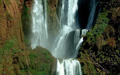

What Ouzoud Falls is
Ouzoud Falls lies near Aït Taguella in Azilal Province, within the M'Goun UNESCO Global Geopark. The falls occupy the northern foothill zone of the Central High Atlas, where folded mountain rocks give way locally to incised valleys and stepped limestone slopes.
The commonly cited 110-metre height describes the complete three-tier descent rather than one uninterrupted vertical plunge. Rock ledges divide the water into separate curtains and chutes, and the active width changes as discharge rises or falls.
Jurassic limestone and a stepped brink
Jurassic limestone forms the main structural framework of the falls. The rock belongs to the sedimentary successions of the Central High Atlas, deposited in an earlier basin and later folded and uplifted as the Atlas Mountains developed. River incision has exposed these beds at the waterfall and in nearby gorges.
Limestone is both resistant enough to maintain steep ledges and soluble along joints and bedding planes. Flow exploits those weaknesses, while turbulence and transported sediment wear the channel. Unequal resistance among beds helps preserve the stepped profile instead of a single even face.
Small upland basin
Runoff gathers through a limestone-dominated High Atlas watershed.
Three linked tiers
Irregular ledges split the descent among curtains, channels, and shorter drops.
Incised valley
The stream regathers at the foot and continues toward the Oued El Abid.
Rainfall, karst pathways, and changing flow
The Oued Ouzoud watershed is part of the Oued El Abid sub-basin. Its limestone formations and karstic features allow water to move both across the surface and through fractures and solution openings, linking runoff and groundwater within the catchment.
Discharge varies with rainfall over the mountain basin. Wetter periods spread water across more of the ledges and strengthen the main curtains; extended dry conditions expose more bedrock and concentrate flow in lower channels. Short, intense storms can produce rapid runoff and much higher, sediment-bearing flow, so a single view of the falls does not represent its full hydrologic range.
Mediterranean mountain controls
The catchment has a Mediterranean mountain climate with strong variation through the year and from one elevation to another. Most effective rainfall arrives outside the hot, dry summer, while Atlantic weather systems, local relief, and episodic storms influence how much water reaches the channel.
Elevation moderates temperatures relative to Morocco's lower plains, but summer evaporation and limited rain reduce catchment moisture. The seasonal balance among rainfall, infiltration into limestone, soil storage, and evaporation governs the water supplied to the brink.
From the High Atlas to Atlantic drainage
Below the falls, the Oued Ouzoud runs into the Oued El Abid network. The El Abid is a major tributary of the Oum Er-Rbia, which carries water westward across central Morocco to the Atlantic Ocean. Ouzoud is therefore a local gradient break nested within a much larger regional river system.
The record connects naturally to the waterfalls hub, the rivers hub, the Atlas Mountains, and the terrain index. Together they place the waterfall within mountain uplift, limestone erosion, seasonal runoff, and basin-scale drainage.