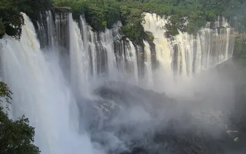

What Kalandula Falls is
Kalandula Falls, also spelled Calandula Falls, lies in Malanje Province in north-central Angola. The Lucala approaches across gently rolling upland terrain, then spills over a broad, inward-curving brink. At higher stages, numerous parallel curtains and chutes occupy much of the rim; lower flow exposes rock ribs that divide the descent.
Figures of roughly 105 metres in height and 400 metres in width are widely reported. They describe the overall landform rather than a uniform wall: the crest is irregular, the water is distributed unevenly, and the visible width changes with discharge.
Plateau edge, rock rim, and lower valley
The falls stand within the western-draining part of Angola's interior plateau. Here the Lucala encounters an abrupt break in gradient between its broader upstream course and the more deeply cut valley below. Resistant bedrock maintains the rim while fractures, ledges, and uneven surfaces divide the falling water.
Erosion is concentrated at the brink and foot of the falls. Impact, turbulent recirculation, and sediment carried by the river loosen material along weaknesses; repeated removal can enlarge recesses and contribute to slow retreat of the edge. The downstream channel then carries that eroded material away through the confined valley.
Broad upland river
The Lucala approaches through a comparatively open plateau reach.
Curved segmented crest
Rock ribs split the river into curtains, chutes, and smaller side drops.
Confined valley
The river regathers beneath the falls and continues through steeper relief.
Seasonal rainfall changes the active crest
The Lucala gathers runoff from the Angolan uplands before reaching Kalandula. Flow responds to the region's pronounced wet and dry seasons: rains across the catchment raise river stage and spread water across more of the crest, while the dry season narrows and separates the active channels.
This variability changes the falls' appearance without changing its underlying structure. During higher discharge, water can mask steps and rock projections and produce a more continuous curtain. At lower discharge, the geometry of the brink becomes clearer, with individual threads occupying lower points in the rock rim.
Tropical wet and dry controls
North-central Angola has a tropical climate governed by the seasonal movement of rain-bearing air. Most precipitation falls during the warmer wet season, while a cooler dry season brings a long reduction in rainfall. Catchment moisture and river discharge lag and integrate these changes across the uplands.
The waterfall also creates local contrasts. Spray and shade keep surfaces near active channels wetter than the surrounding plateau, whereas exposed rock away from the main flow dries more quickly. These small-scale effects are consequences of relief and water movement rather than a separate regional climate.
From the Lucala to the Atlantic
Below Kalandula Falls, the Lucala continues westward and ultimately joins the Kwanza River. The Kwanza then crosses Angola to the Atlantic Ocean, placing the waterfall within a much larger basin that links humid and seasonally wet uplands to lower western terrain.
Kalandula therefore connects the waterfalls hub with the rivers hub and the terrain index. Its physical geography is best understood as a gradient break inside an active drainage network, not as an isolated cliff.