
What Augrabies Falls is
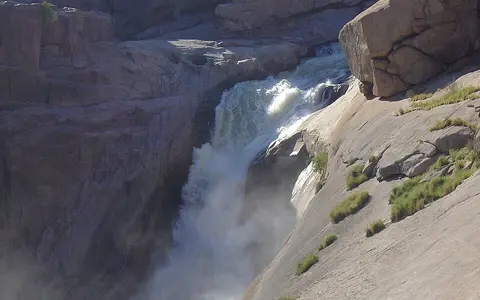
Augrabies Falls is a waterfall and gorge threshold on the Orange River in the Northern Cape of South Africa. Above the brink, the river spreads through a wider rock-strewn reach and separates around channels and islands. Near the falls, much of that flow is gathered into a main chute that drops about 56 metres.
The landform is best read as a transition in river geometry. A comparatively broad upstream valley gives way at the falls to a confined downstream course, where the Orange River runs through an approximately 18-kilometre gorge before less restricted valley forms reappear farther downstream.
Ancient rock and a fault-guided edge
The falls cross old metamorphic rocks dominated locally by granite gneiss, including the reddish to pink gneiss characteristic of the Augrabies landscape. These crystalline rocks are resistant, but they are not uniform: faults and joints provide lines of weakness that channel erosion can exploit.
Over time, falling water, transported sediment, and pressure changes within the plunge zone have enlarged fractures and removed loosened blocks. The waterfall edge has consequently retreated eastward along structural weaknesses, while the river below has deepened and extended its gorge.
Divided rock channels
Channels separate around exposed bedrock before converging near the main fall.
Fault-controlled drop
Weaknesses in resistant gneiss help locate the steep descent.
Incised gorge
The Orange River leaves the plunge reach through a narrow bedrock corridor.
Headwater rainfall, regulation, and flood pulses
Local rainfall around Augrabies is low and irregular, yet the waterfall belongs to a river with a very large upstream drainage area. Much of the Orange River's water originates far to the east in wetter highlands, while the Vaal River and other tributaries add flow gathered across South Africa's interior.
Discharge at the falls therefore reflects weather and water management across the wider Orange–Vaal system rather than conditions beside the gorge alone. Dams, irrigation withdrawals, and seasonal releases modify the hydrograph. During large basin floods, water spreads across additional rock channels and subsidiary falls; at lower flows, exposed bedrock divides the river more sharply and concentrates it in the main channel.
A perennial river in a semi-arid setting
The Augrabies area has a semi-arid interior climate, with very hot summers, cold winter nights, and roughly 119 millimetres of average annual rainfall. Most rain falls in the warmer part of the year, often in short storms, but high evaporation and sparse local runoff keep the surrounding terrain dry.
This contrast is central to the falls' geography. The perennial Orange River carries water across a rocky landscape whose local climate could not sustain a river of comparable size by itself. The gorge also creates sharp local relief, with shaded walls, spray near high flows, and bare heat-retaining rock producing conditions that differ over short distances.
From interior basin to Atlantic drainage
Augrabies Falls occupies the lower half of the Orange River system, downstream from the Orange–Vaal confluence and upstream from the river's increasingly rugged western reaches. Beyond the gorge, the Orange continues through dry Nama Karoo and desert-margin country before reaching the Atlantic Ocean on the South Africa–Namibia boundary.
The falls are therefore both a local bedrock feature and a basin marker. They connect the waterfalls hub with the rivers hub and the terrain index, showing how a sharp gradient break can reorganize the form of a continental river without interrupting its wider drainage route.